


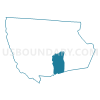
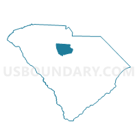
Simpson Voting District, Fairfield County, South Carolina
About
Outline

Summary
| Unique Area Identifier | 665689 |
| Name | Simpson Voting District |
| County | Fairfield County |
| State | South Carolina |
| Area (square miles) | 37.19 |
| Land Area (square miles) | 37.09 |
| Water Area (square miles) | 0.11 |
| % of Land Area | 99.71 |
| % of Water Area | 0.29 |
| Latitude of the Internal Point | 34.29014200 |
| Longtitude of the Internal Point | -81.03563650 |
Maps

Graphs
Select a template below for downloading or customizing gragh for Simpson Voting District, Fairfield County, South Carolina


Neighbors
Neighoring Voting District (by Name) Neighboring Voting District on the Map
- Blythewood #1 Voting District, Richland County, SC
- Blythewood #2 Voting District, Richland County, SC
- Greenbrier Voting District, Fairfield County, SC
- Hickory Ridge Voting District, Fairfield County, SC
- Ridgeway Voting District, Fairfield County, SC
- South Winnsboro Voting District, Fairfield County, SC
- Winnsboro Mills Voting District, Fairfield County, SC
- Winnsboro No. 2 Voting District, Fairfield County, SC
Top 10 Neighboring County Subdivision (by Population) Neighboring County Subdivision on the Map
- Blythewood CCD, Richland County, SC (27,231)
- Winnsboro South CCD, Fairfield County, SC (11,548)
- Ridgeway CCD, Fairfield County, SC (6,156)
- Camp Ground CCD, Richland County, SC (5,505)
Top 10 Neighboring Place (by Population) Neighboring Place on the Map
Top 10 Neighboring Unified School District (by Population) Neighboring Unified School District on the Map
Top 10 Neighboring State Legislative District Lower Chamber (by Population) Neighboring State Legislative District Lower Chamber on the Map
Top 10 Neighboring State Legislative District Upper Chamber (by Population) Neighboring State Legislative District Upper Chamber on the Map
- State Senate District 22, SC (126,092)
- State Senate District 19, SC (105,577)
- State Senate District 17, SC (88,026)
Top 10 Neighboring 111th Congressional District (by Population) Neighboring 111th Congressional District on the Map
Top 10 Neighboring Census Tract (by Population) Neighboring Census Tract on the Map
- Census Tract 9604, Fairfield County, SC (6,273)
- Census Tract 101.02, Richland County, SC (6,219)
- Census Tract 9603, Fairfield County, SC (6,156)
- Census Tract 102, Richland County, SC (5,505)
- Census Tract 9605, Fairfield County, SC (5,275)